KEW ILLUSTRATED, 1891
Format: Online exhibition
Venue: Kew Court House
9/2016 – 2/2017
Curators: Robert Baker, Suzanne McWha
Digitisation: Andrew Mackinnon
At the beginning of the 1890s, the Kew businessman and Town Councillor, Henry Kellett, commissioned J.F.C. Farquhar to photograph scenes of Kew. These scenes included panoramas as well as pastoral scenes. The resulting set of twelve photographs was assembled in an album, Kew Where We Live, from which customers could select images for purchase. The preamble to the album describes that the photographs used the ‘argentic bromide’ process, now more commonly known as the gelatine silver process. This form of dry plate photography allowed for the negatives to be kept for weeks before processing, hence its value in landscape photography. The resulting images were considered to be finely grained and everlasting. Evidence of the success of Henry Kellett’s venture can be seen today, in that some of the photographs are held in national collections. It is believed that the Kew Historical Society’s copy of the Kellett album is unique.
 THE POST OFFICE
JFC Farquhar, 1891
Photograph, 240 x 160 mm , Kew Historical Society Inc.
Copyright: All Rights Reserved
A panoramic photograph of the junction of High Street and Cotham Road. The photographer centres the point-of-view on the Kew Post Office and adjacent Court House. These were designed in the Queen Anne style by the Public Works Department’s architect J Harvey and completed in 1888. The complex is important because it demonstrates a departure from the contemporaneously favoured High Victorian Classical to the Queen Anne style in the design of civic buildings. The earlier Jubilee Fountain in front of the Post Office was erected by the Kew Borough Council to commemorate the Golden Jubilee of Queen Victoria in 1887. It was created to a design of the architects Reed, Henderson and Smart. The fountain was later relocated to the Alexandra Gardens to make way for the Kew War Memorial. The tram tracks in High Street were used by the horse tram, which ran from the Victoria Street Bridge to the Boroondara General Cemetery. The tram was replaced by an electrified service in 1915.
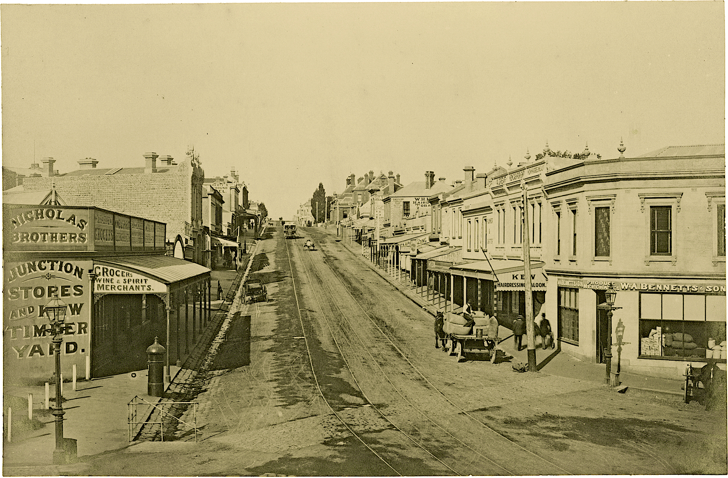 HIGH STREET, KEW
JFC Farquhar, 1891
Photograph, 240 x 160 mm , Kew Historical Society Inc.
Copyright: All Rights Reserved
In 1891, High Street was the centre of commercial activity in the Municipality of Kew. It was unpaved and edged with deep bluestone gutters, which were designed to channel the significant flow of storm water down the hill to and beyond the Junction. On either side of the entrance to the shopping strip are two cast iron gas lamps that provided the only public street lighting before the Post Office was reached. Most shops, including the Nicholas Brothers’ Junction Storefeatured cast iron verandas. Further up the hill, Dougherty’s Greyhound Hotel was by this stage a local institution. Apart from the horse-drawn tram, the main form of personal and commercial transport in this period remained the horse, horse and cart, or buggy. The panoramic view predates the widening of High Street in the 20th century, and thus includes the original alignment of buildings on the south side. These included Henry Kellett’s shop.
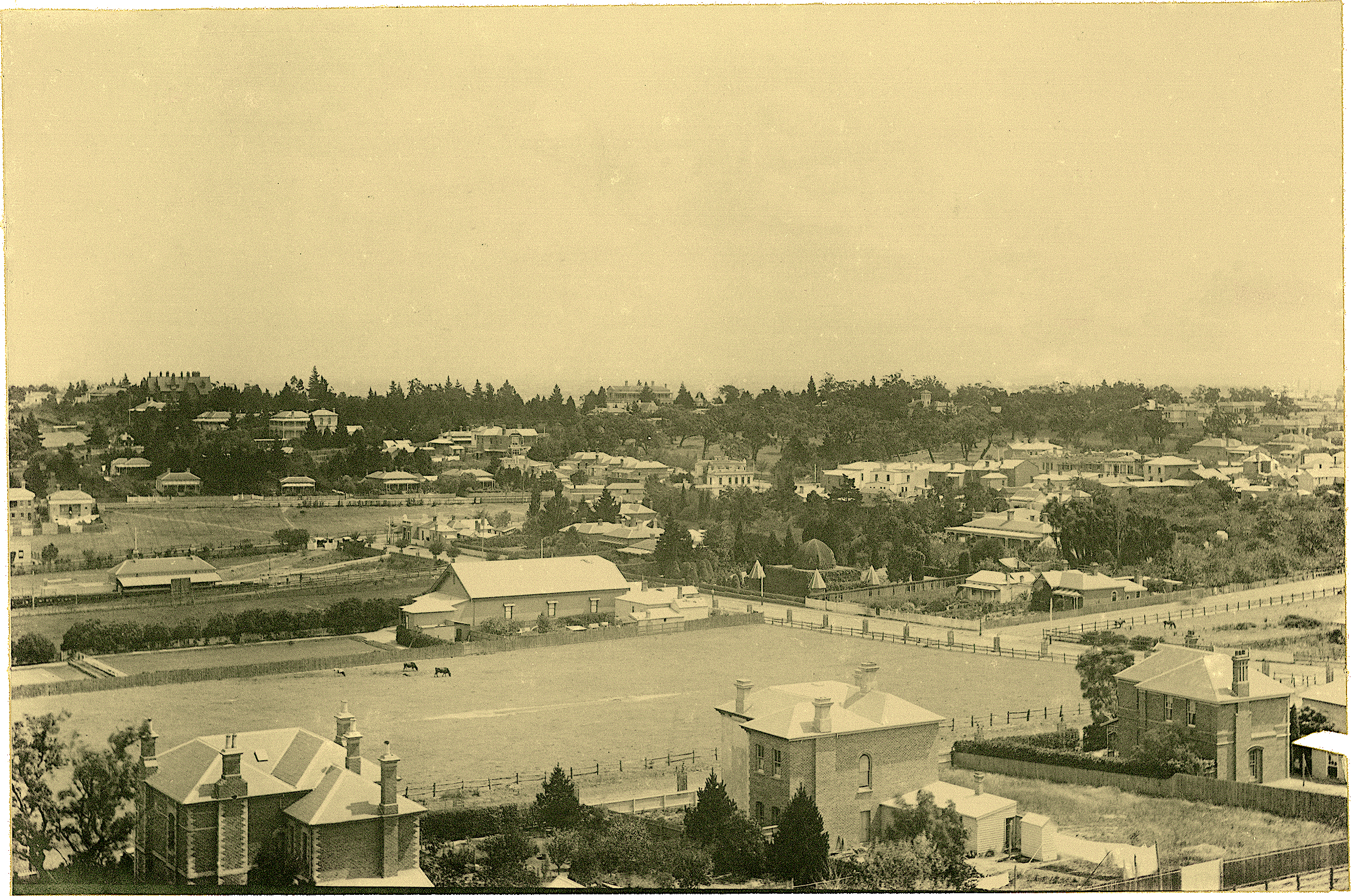 BIRD”S EYE VIEW LOOKING WEST
JFC Farquhar, 1891
Photograph, 240 x 160 mm , Kew Historical Society Inc.
Copyright: All Rights Reserved
Before true aerial photography became possible, photographers such as J.F.C. Farquhar were compelled to shoot their images from the highest vantage point. Here, it is presumed to be the roof of Xavier College, from which the panoramic view extends west towards the rise of Studley Park. The houses in the foreground face the southern end of Gellibrand Street. Wellington Street is at an angle to the camera with the Queen Street intersection on the near right. The wooden building behind the large horse paddock on the other side of Gellibrand Street is the Kew Recreation Hall, built 1888, demolished 1960. It was reputed to have one of the finest dancing floors in or around Melbourne. The Bowling Green at the rear of the Hall belonged to the Kew Bowling Club. Further west is the Kew Railway Station on Denmark Street, opened to the public in 1887. At this period, much of Studley Park was locked up in large landholdings, dominated by large mansions such as ‘Byram’.
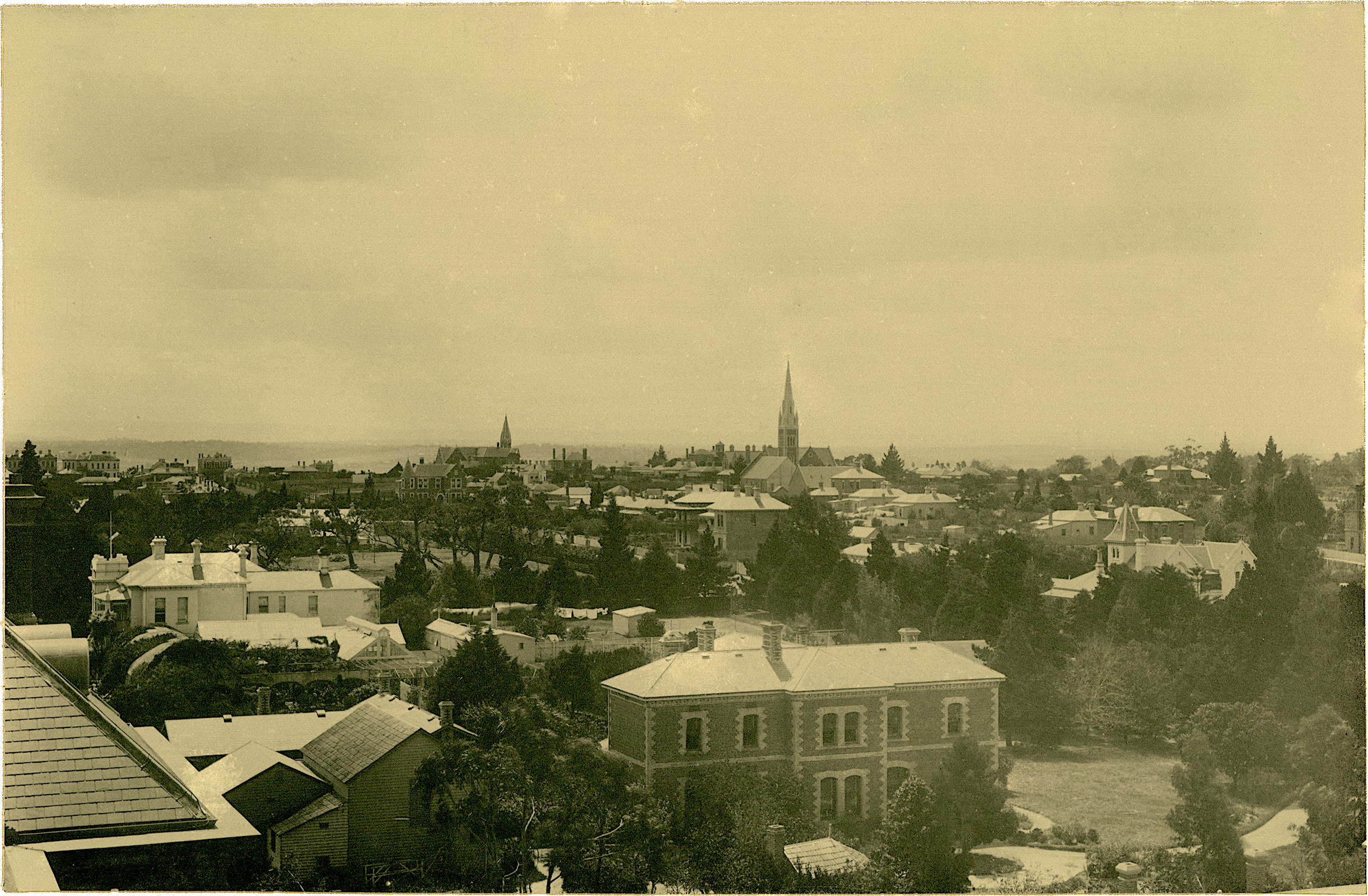 BIRD”S EYE VIEW LOOKING NORTH
JFC Farquhar, 1891
Photograph, 240 x 160 mm , Kew Historical Society Inc.
Copyright: All Rights Reserved
This panoramic view was probably taken from the same vantage point as in Plate 2. It invites the viewer to look down on the buildings and streets of Kew, and across to the distant horizon. Mansions and solid bourgeois villas dominate the view of Charles and Wellington Streets. The imposing spires of the Presbyterian and Methodist Churches, built in one of the highest areas of Kew, can be seen in the distance. In the foreground, the photographer includes three significant mansions: Molina, Roxeth and Elsinore. Molina, in the foreground, and the group of weatherboard buildings in its yard was used at this stage for the privately operated ‘Kew High School’ (founded 1872). Roxeth, the home of Herbert Henty can be identified by its distinctive four-sided tower. All three buildings are now part of Trinity Grammar. Other built structures observable in the photograph include Wilton (now the Kew RSL), designed by Guyon Purchas for Dr William Walsh in 1886, and the only known image of the Prospect Hill Hotel prior to the renovation of 1935.
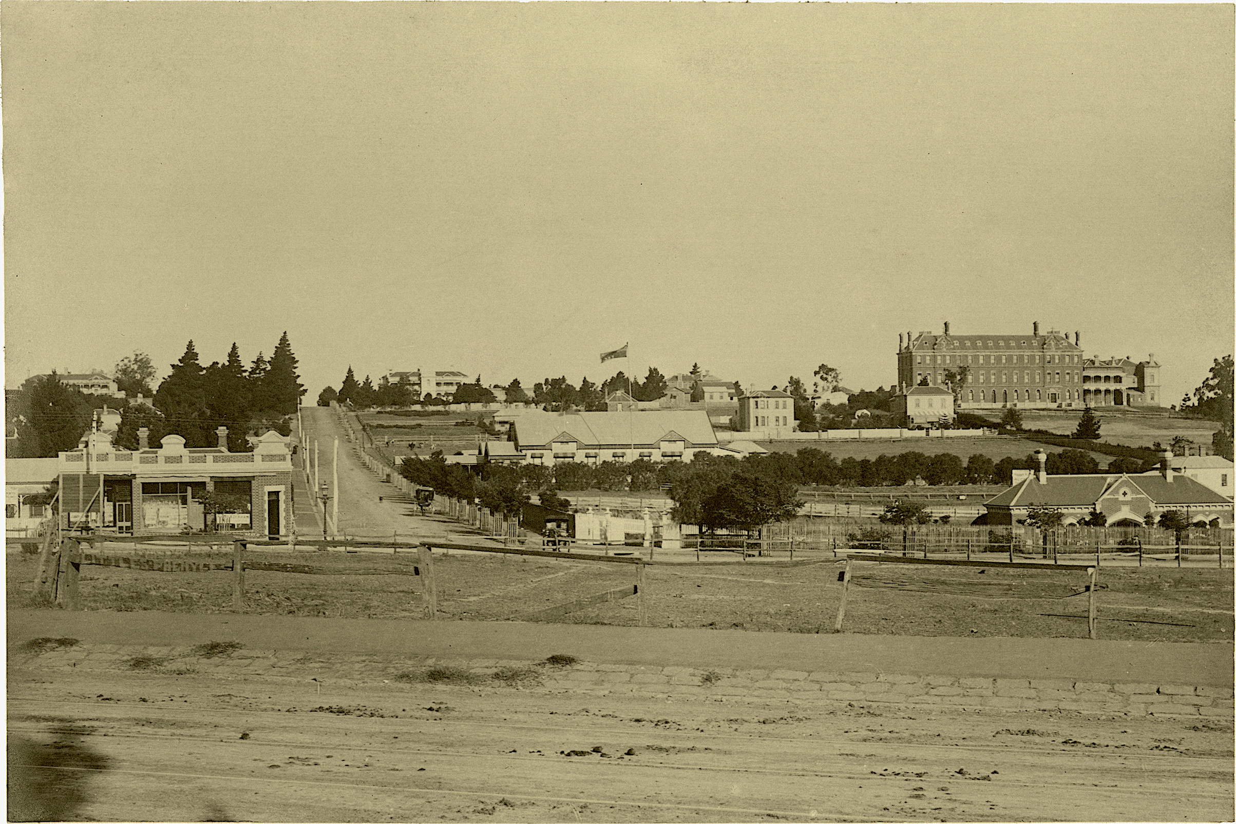 WELLINGTON STREET, FROM HIGH STREET
JFC Farquhar, 1891
Photograph, 240 x 160 mm , Kew Historical Society Inc.
Copyright: All Rights Reserved
Very few of the natural or built features in this panoramic photograph of Wellington Street remain. The open land between High Street South and Denmark Street, then known as O’Shannessy’s Paddock, was to become a residential subdivision at the beginning of the 20th Century. On the far side of Denmark Street, bordered by a picket fence, is the Kew Railway Station (demolished 1957). Further east, the large building with the flagpole is the Kew Recreation Hall (demolished 1960), which was the centre of civic life for almost a century. The building was used for dances, civic functions and exhibitions. A bowling green, tennis courts, and a cricket ground surrounded the Hall. The dominant building in the photograph is Xavier College, founded in 1872 by the Society of Jesus. The first classes for pupils were held in 1878. It is presumed that Farquhar used its roof for two of his bird’s eye views.
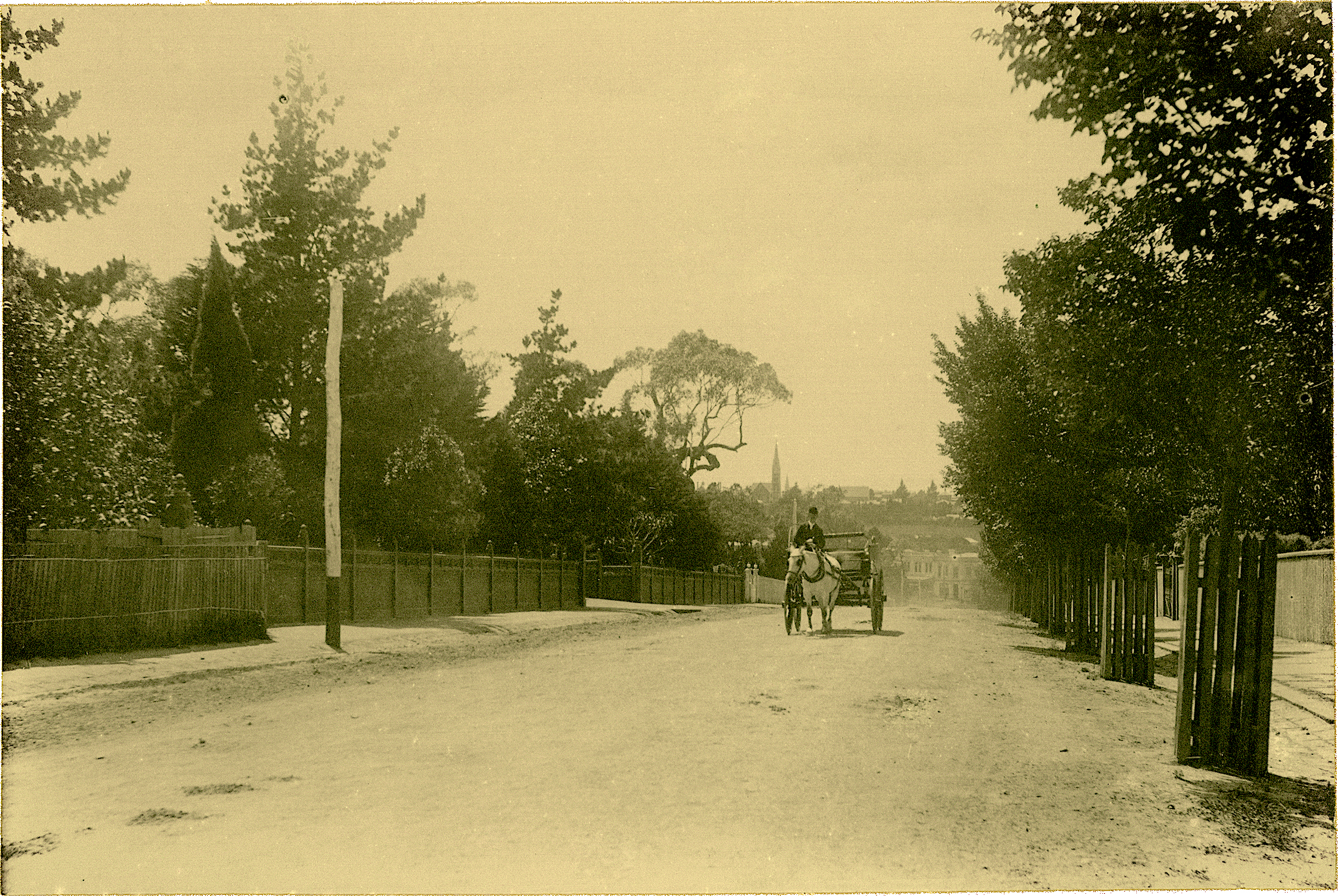 STUDLEY PARK ROAD
JFC Farquhar, 1891
Photograph, 240 x 160 mm , Kew Historical Society Inc.
Copyright: All Rights Reserved
In this view of Studley Park Road, looking northeast to the Junction, the photographer invites the viewer to participate in a point-of-view that emphasises the elevated, tranquil vantage point of the hill in contrast to the bustling commercial area in the distance. The view emphasises the exclusiveness of Studley Park, with its high fences behind which a number of significant Kew mansions were concealed. Contemporary advertisements for the sale of mansions in Studley Park Road often included fulsome descriptions of their elaborate formal gardens, as well as paddocks for grazing, stabling and dairies. None can be seen here. The use of high, protective wooden pickets to surround the newly planted avenue of elms on the south side of the road appears to be typical of the period. Similar examples can be seen in early photographs of Wellington and Princess Streets. The horse and carriage, selected as a central focus of the view, reinforces the residential, exclusive nature of this part of Kew in the early 1890s.
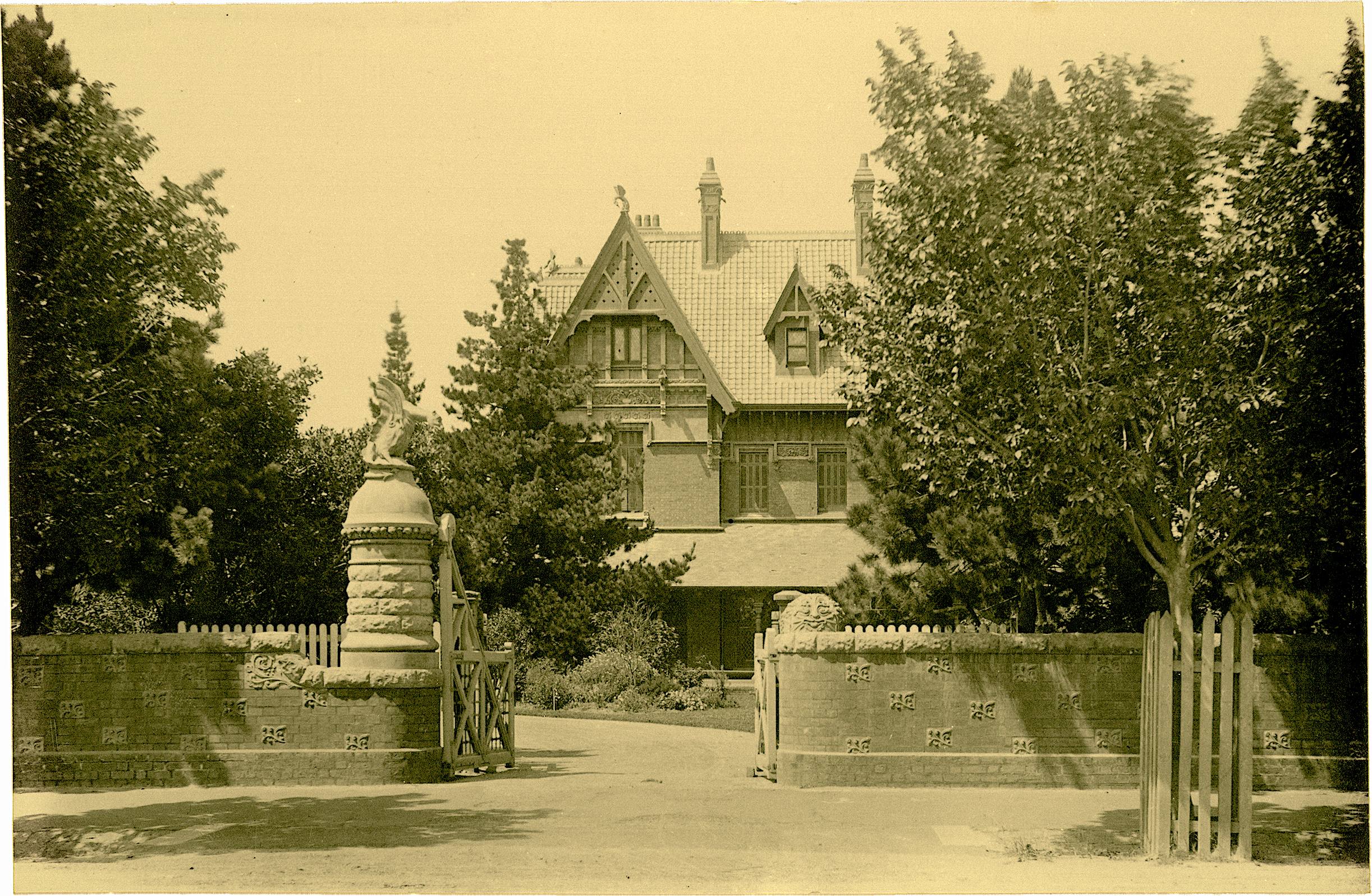 A VIEW IN STUDLEY PARK ROAD
JFC Farquhar, 1891
Photograph, 240 x 160 mm , Kew Historical Society Inc.
Copyright: All Rights Reserved
This is the earliest known photograph of the exterior of Byram (later Tara Hall). It shows the original red brick fence, its asymmetrical gate and gateposts, with a large terra cotta gargoyle surmounting the higher of the two. The architect, Edward Kilburn designed Byram in the Arts & Crafts style for the industrialist George Ramsden. Construction began in 1888 and was reputed to have lasted three years. The mansion had frontages to Studley Park Road and Stevenson Street, including gardens laid out with great taste, including pleasure grounds, tennis lawn, fruit and flower garden, and paddock. The size of many of the trees in the garden indicate that many survived from the garden of Clifton Villa, the previous single-storeyed house built on the site by the Stevenson brothers. Byram had views to Melbourne and Port Phillip Bay. The house was demolished in 1960, despite opposition from the National Trust (Victoria), and its gardens subdivided into residential allotments.
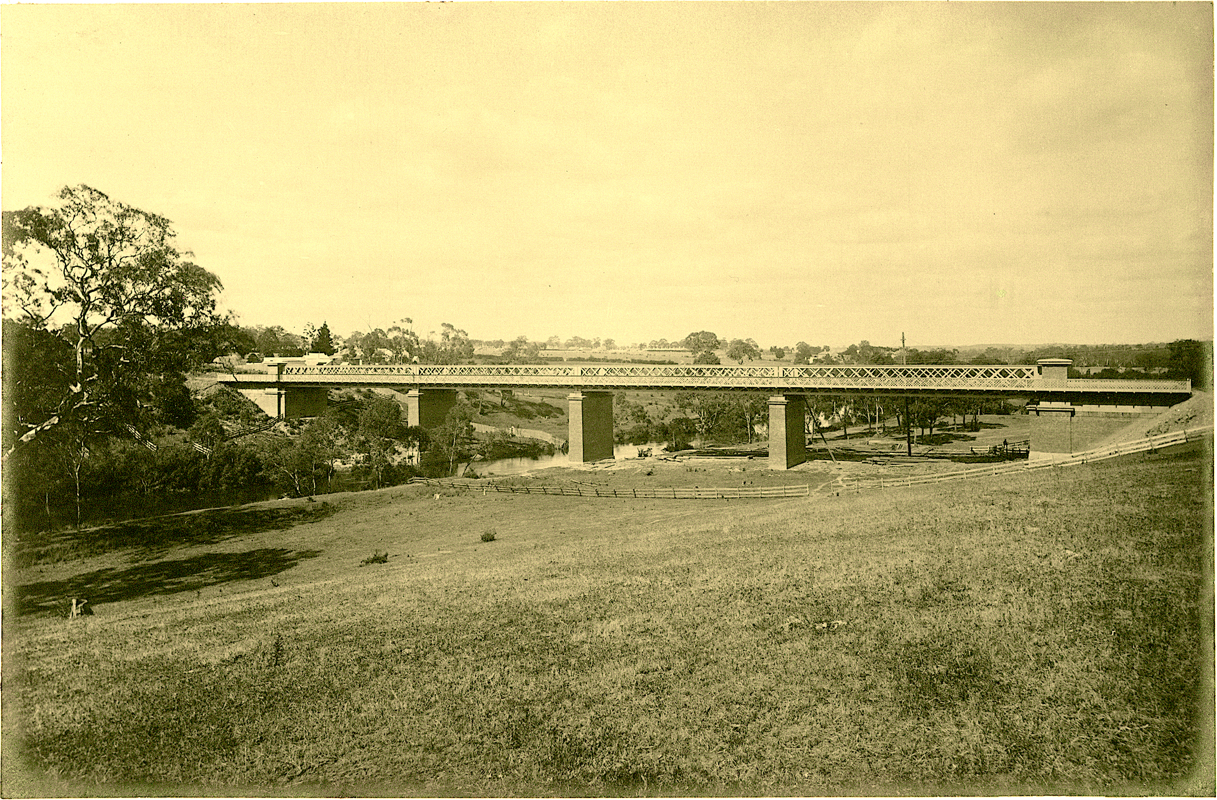 RAILWAY BRIDGE OVER THE YARRA
JFC Farquhar, 1891
Photograph, 240 x 160 mm , Kew Historical Society Inc.
Copyright: All Rights Reserved
Completed in November 1890, the railway viaduct (now the Chandler Highway Bridge) linked Kew and Fairfield. The viaduct is significant as the most substantial extant engineering remnant of the Outer Circle Railway Line. Opened in March 1891, the viaduct crossed the Yarra River in a single span, atop three supporting brick pillars. Following the closure of the railway line in 1927, and the construction of the Chandler Highway in 1930, the bridge was used for vehicular traffic. In 1891 when this panoramic photograph was taken, the grounds of what was then the Kew Lunatic Asylum extended down to the River and eastward beyond the viaduct. The landscape surrounding the Asylum was planted with traditional exotic trees such as Oaks, Pines and Cedars, and landmark trees from northern Australia such as the Hoop Pine. Remnant indigenous trees such as the River Red Gum, Yellow Box and Lightwood were scattered around the site, including beside the Yarra River.
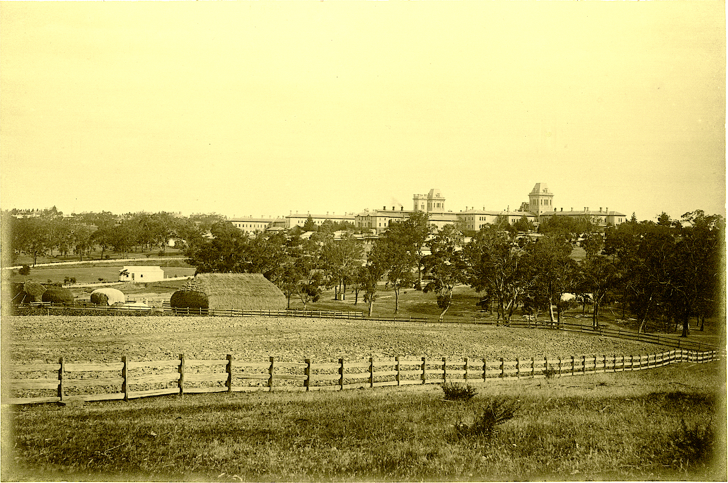 KEW ASYLUM AND GROUNDS
JFC Farquhar, 1891
Photograph, 240 x 160 mm , Kew Historical Society Inc.
Copyright: All Rights Reserved
When the Kew Lunatic Asylum was opened in 1871, its extensive 340 acres of grounds were intended for farming, agriculture and recreation for the inmates. The point-of-view chosen by Farquhar for this panoramic photograph focuses on the ordered open fields, haystacks and remnant trees that extended from the foreground to the rear of the Asylum. The inmates are the absent players in this pastoral idyll. In 1891, The Argus reported on the Annual Asylum Picnic: “Wednesday saw the Kew picnic, the yearly festival of the mad folks and their keepers. Once a year the public subscribes for cakes and ale for all these mad folks, and their keepers, from superintendent to lowest wardsman, turn out, and use their best endeavours to make one day in the year sanely merry.” Regardless of such merriment, the Asylum’s development and ongoing status were frequently a source of disquiet to the residents of Kew, who regularly petitioned the State Government for its removal. Despite these views, the Asylum was to remain a functioning institution from 1871 to 1988.
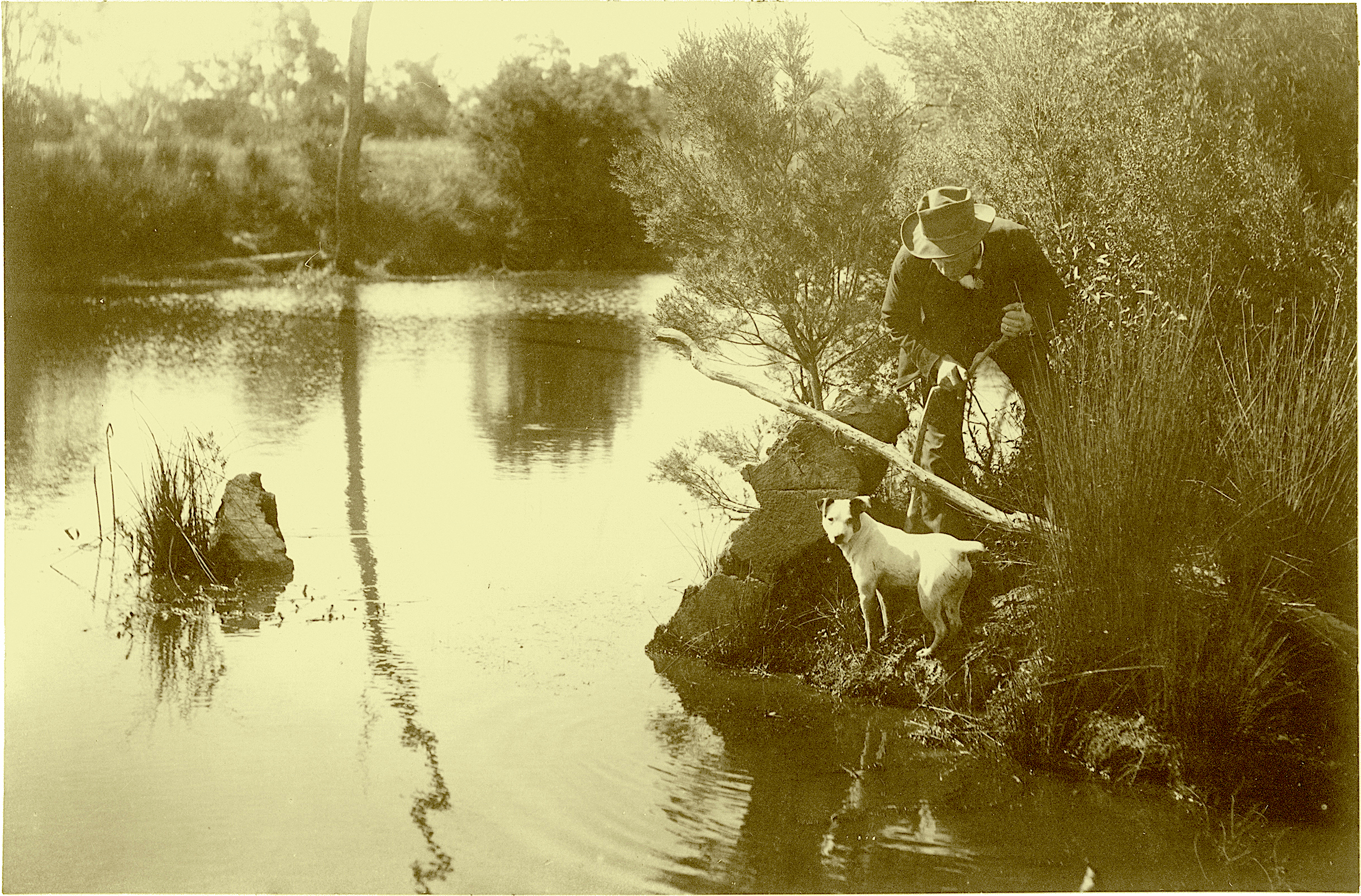 RATTING ON THE YARRA
JFC Farquhar, photographer, 1891
Photograph, 240 x 160 mm , Kew Historical Society Inc.
Copyright: All Rights Reserved
The final three plates in the Kellett album provide contrasting views of the Yarra River and its relationship to Kew. In Farquhar’s close-up portrait of the rat catcher and his dog, the photographer excludes any extraneous data that otherwise might have provided a spatial or motivational context. The contemporary or the present day viewer is required to construct a narrative to explore or understand what is occurring. The title of the picture might incline a viewer to believe that what they see is an exercise in vermin control, and that the rat concerned might be an introduced black or brown rodent. A more likely scenario is that the rat catcher is focussed on catching ‘rakali’, a native water-rat once widely trapped for its fur. The trapping of rakali for use in the manufacture of fashionable clothing accelerated as introduced furs such as musquash became more expensive. It was not until 1938 that rakali were granted protected status.
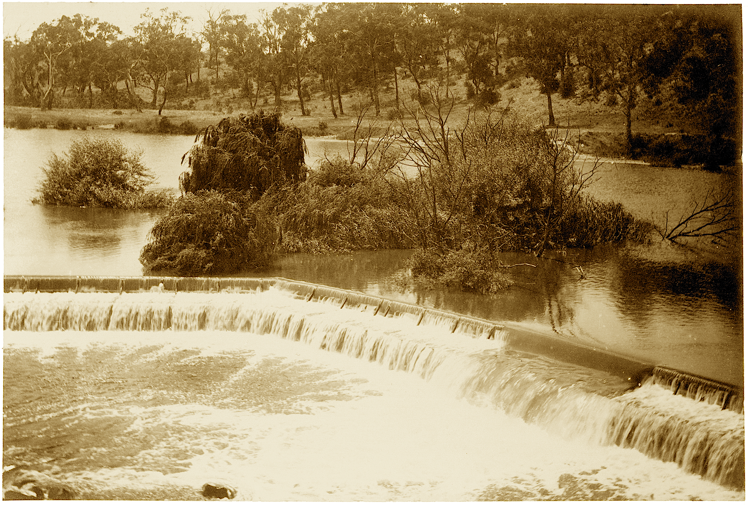 DIGHT’S FALLS
JFC Farquhar, 1891
Photograph, 240 x 160 mm , Kew Historical Society Inc.
Copyright: All Rights Reserved
Dight’s Falls in Studley Park is an artificial weir built on a natural rock bar across the Yarra. The weir was built in the 1840s to provide water to the ‘Ceres’ flour mill, one of the earliest industrial sites in Melbourne. The falls were later to be named after the owner of this mill.In 1888, William Guilfoyle, Director of the Melbourne Botanical Gardens had called for fresh water to be piped from above the weir to the Botanical Gardens, using a pumping station on the Kew side of the Falls, a holding reservoir in Walmer Street and a series of pipes from there to the Gardens. This system was opened in May 1891. Farquhar’s photograph of the man-made weir obscures the industrial activity on both sides of the Falls and focusses solely on the river and the surrounding natural vegetation. The photograph probably predates the disastrous flooding of the Yarra River in July 1891, the greatest to have occurred in the Colony since the foundation of Melbourne.
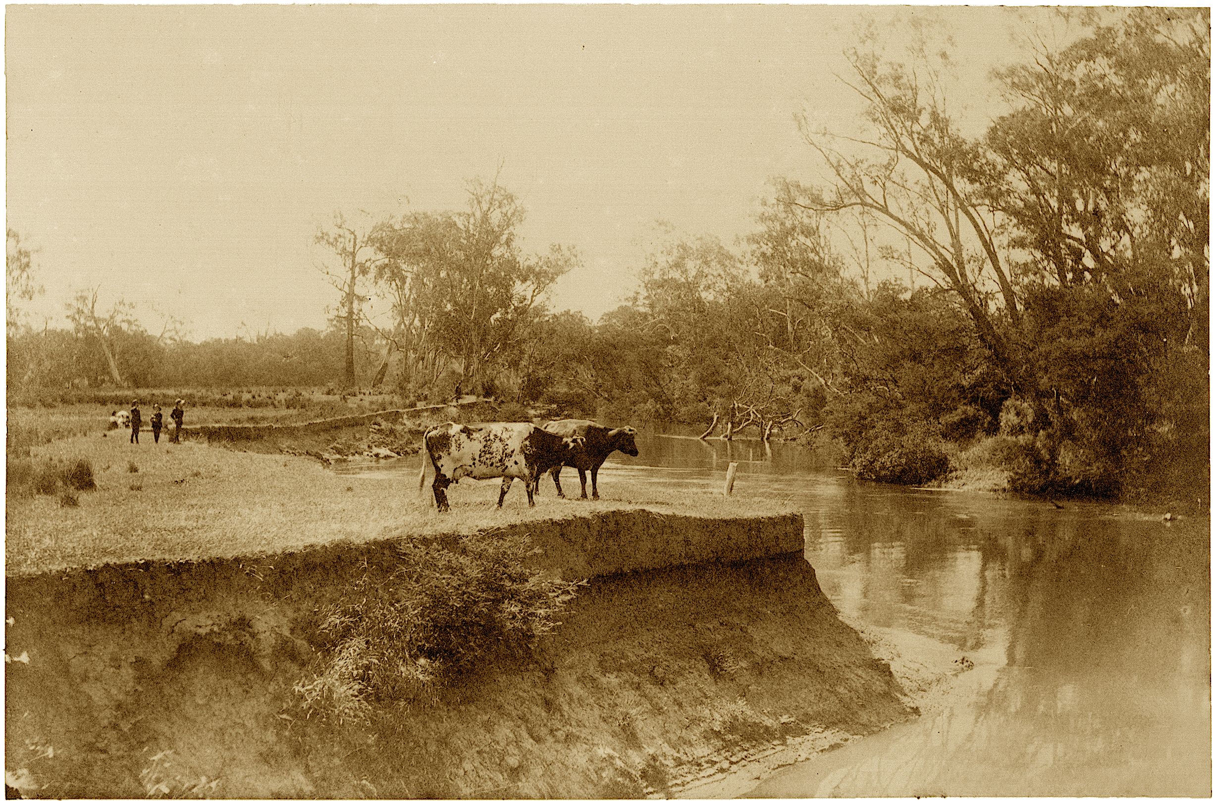 THE YARRA IN HYDE PARK
JFC Farquhar, photographer, 1891
Photograph, 240 x 160 mm , Kew Historical Society Inc.
Copyright: All Rights Reserved
Hyde Park is now a small recreation reserve bordered by Willsmere and Kilby Roads and White Avenue. In 1982, Hyde Park was cut off from the Yarra River by the construction of the Eastern Freeway. The building of the latter was to transform the natural landscape, including the Yarra, as well as Hyde Park. The construction of the Freeway makes it difficult to view the scene with the photographer’s eye. Today’s Hyde Park is located on land purchased in 1847 by John Cowell, and in 1851 Catherine Cowell, yet the scene selected by the photographer may well have been located on farmland owned by the Wills family. Farquhar’s point-of-view emphasises both the pastoral and recreational elements of the scene: the grazing cows, three boys, and in the distance two figures, seated on the bank with a parasol. By 1891, an environmental consequence of human activity, including farming, was deforestation, leading to the erosion of the south bank of the Yarra. In contrast, the land on the Alphington side of the river in 1891 included remnant bushland.
We hope that you enjoyed viewing this online exhibition. If you enjoyed it, please contact The Secretary of KHS.
Copyright: Kew Historical Society Inc 2020