 Have you always wanted to know more about our heritage, and the historic built structures in our streets. You can find out more by choosing one of our new self-guided walking tours to explore Kew and Kew East on foot, and at your own pace. Each walk comes with a tour map as well as photos and background information for specific sites along the way.
Click on the links below to open each two-sided guide and choose to print in either colour or black and white. Alternatively, using your mobile phone or tablet, you may prefer to scan the QR code on the brochure to follow the tour on your device. Please contact info@kewhistoricalsociety.org.au if you have any queries.
 STUDLEY PARK
Studley Park walk (PDF document 2.7 MB)
Studley Park Road, Nolan Avenue, Walmer Street, Young Street, Stevenson Street, Hodgson Street.
Distance 2.5 km | Duration 1 hour
 SACKVILLE STREET
Sackville Street walk (PDF document 2.5 MB)
Sackville Street.
Distance 1.7 km | Duration 45 minutes
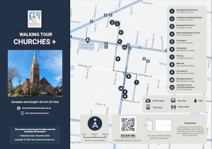
 CHURCHES +
Churches and More walk (PDF document 2.9 MB)
Highbury Grove, St John’s Parade, Wellington Street, Glenferrie Road, Selbourne Road, Fitzwilliam Street.
Distance 1.7 km | Duration 45 minutes
 KEW EAST
Kew East walk (PDF Document 1.7 MB)
Strathalbyn Street, Windella Avenue, Minto Street, Birdwood Street, Kilby Road, Belford Road, Valerie Street, High Street.
Distance 2.2 km | Duration 45 minutes
 PAKINGTON STREET +
Pakington Street and More walk (PDF document 3.3 MB)
Pakington Street, Malmsbury Street, Walpole Street, Eglinton Street, Peel Street.
Distance 2.2 km | Duration 1 hour
These tours are for personal educational use. Kew Historical Society Inc. is not liable for any injury, incident or consequential damages resulting from the use of these materials. Participants are encouraged to follow traffic rules, bring water and wear comfortable shoes.
Brochures designed by EG Graphics.